Skip to contents

[Experimental] This function obtains the information about of an eLTER sensor (e.g. https://deims.org/sensors/3845475c-4aec-4dd7-83b4-0ab6ba95db35) provided in DEIMS-SDR catalogue.

Usage

get_sensor_info(sensorid, show_map = FALSE)

Arguments

sensorid

A 
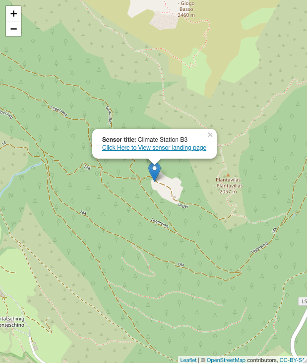
character. It is the DEIMS ID of sensor make from DEIMS-SDR website. DEIMS ID information here. The DEIMS.iD of sensor is the URL for the sensor page.

show_map

A boolean. If TRUE a Leaflet map with occurrences is shown. Default FALSE.

Value

The output of the function is a tibble with main features of the activities in a site, and a leaflet map plot.

The function output

Map of position of the "Climate Station B3" sensor

Author

Alessandro Oggioni, phD (2020) oggioni.a@irea.cnr.it

Examples

# only table of sensor information
sensor_B3 <- get_sensor_info(
  sensorid =
    "https://deims.org/sensors/3845475c-4aec-4dd7-83b4-0ab6ba95db35",
  show_map = TRUE
)
sensor_B3
#> Simple feature collection with 1 feature and 13 fields
#> Geometry type: POINT
#> Dimension:     XY
#> Bounding box:  xmin: 10.59189 ymin: 46.69173 xmax: 10.59189 ymax: 46.69173
#> Geodetic CRS:  WGS 84
#> # A tibble: 1 × 14
#>   title              abstract        uri   type  created changed relat…¹ conta…²
#> * <chr>              <chr>           <chr> <chr> <chr>   <chr>   <list>  <list> 
#> 1 Climate Station B3 "Near-real tim… http… sens… 2020-0… 2022-1… <df>    <df>   
#> # … with 6 more variables: geography <POINT [°]>, elevation <int>,
#> #   sensorType.label <chr>, sensorType.uri <lgl>,
#> #   resultAcquisitionSource <chr>, observedProperty <list>, and abbreviated
#> #   variable names ¹​relatedSite, ²​contacts

# print the map of the sensor
Licor <- get_sensor_info(
  sensorid =
    "https://deims.org/sensors/4a7ad644-f2e7-4224-965b-ec5ef5365655",
  show_map = FALSE
)
Licor
#> Simple feature collection with 1 feature and 13 fields
#> Geometry type: POINT
#> Dimension:     XY
#> Bounding box:  xmin: 68.6769 ymin: 60.89164 xmax: 68.6769 ymax: 60.89164
#> Geodetic CRS:  WGS 84
#> # A tibble: 1 × 14
#>   title                      abstr…¹ uri   type  created changed relat…² conta…³
#> * <chr>                      <chr>   <chr> <chr> <chr>   <chr>   <list>  <list> 
#> 1 Li-Cor LI-190SA Quantum S… The se… http… sens… 2017-0… 2019-1… <df>    <df>   
#> # … with 6 more variables: geography <POINT [°]>, elevation <lgl>,
#> #   sensorType.label <chr>, sensorType.uri <lgl>,
#> #   resultAcquisitionSource <lgl>, observedProperty <lgl>, and abbreviated
#> #   variable names ¹​abstract, ²​relatedSite, ³​contacts

# Moldaenke FluoroProbe sensor
sensor_FP <- get_sensor_info(
  sensorid = "https://deims.org/sensors/82635223-a4f4-498c-b283-9c95999d9d2f",
  show_map = FALSE
)
sensor_FP
#> Simple feature collection with 1 feature and 13 fields
#> Geometry type: POINT
#> Dimension:     XY
#> Bounding box:  xmin: 8.5741 ymin: 45.80363 xmax: 8.5741 ymax: 45.80363
#> Geodetic CRS:  WGS 84
#> # A tibble: 1 × 14
#>   title                      abstr…¹ uri   type  created changed relat…² conta…³
#> * <chr>                      <chr>   <chr> <chr> <chr>   <chr>   <list>  <list> 
#> 1 Moldaenke FluoroProbe sen… http:/… http… sens… 2022-0… 2022-0… <df>    <df>   
#> # … with 6 more variables: geography <POINT [°]>, elevation <int>,
#> #   sensorType.label <chr>, sensorType.uri <lgl>,
#> #   resultAcquisitionSource <lgl>, observedProperty <list>, and abbreviated
#> #   variable names ¹​abstract, ²​relatedSite, ³​contacts